Introduction
From this page, you can download:
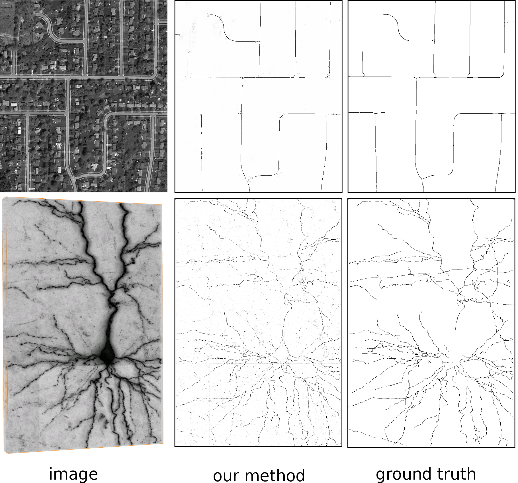
- The source code for the centerline detection algorithm described in the CVPR and PAMI papers referenced below [1,2]. It can be used to detect both centerlines and boundaries in 2D images and multiscale centerlines in 3D. A simplified 3D implementation is also included as a plugin in the latest Vaa3d release.
- The source code for junction enhancement corresponding to the method presented in the ICCV paper referenced below [3].
Centerline and Boundary Detection
Source Code
:
Download the 2D matlab code for [1,2] here (last update 22.12.2016)
– Precompiled binaries for 64-bit linux and Mac OS X are included.
– If you want to compile the mex files yourself use the ‘compileMex.m’ script available in the package.
– For more details see the README.txt file.
3D code for the Vaa3d Plugin is here.
3D matab code is here (last update 22.12.2016)
Precomputed results
:
– Precomputed results and pretrained models on the Aerial dataset are here.
– Precomputed results and pretrained models on the BSDS500 dataset are here.
Junctions Enhancement
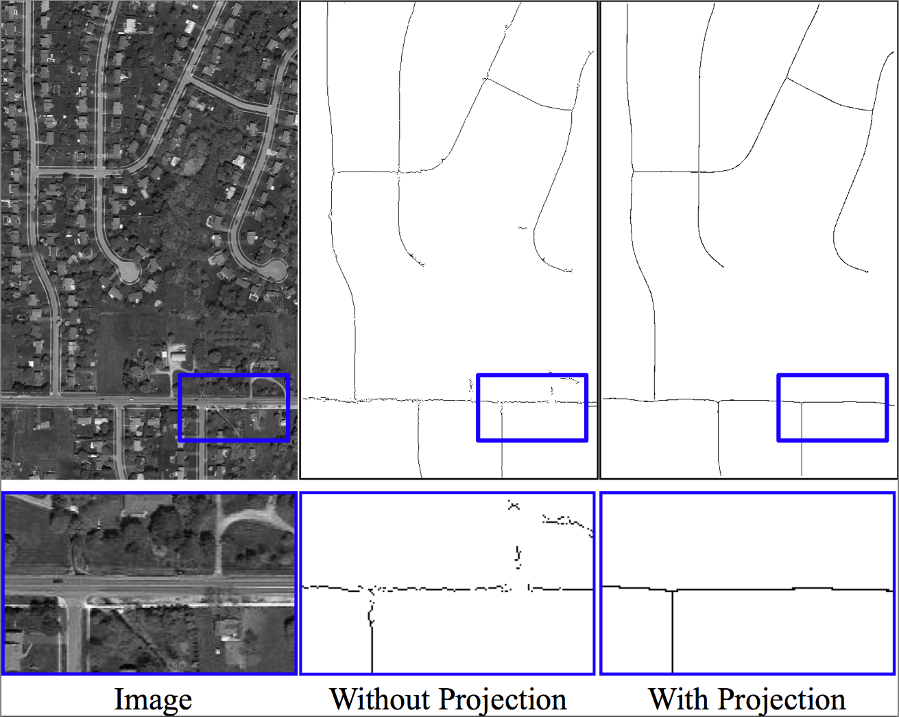
Here you can find the code for the method proposed in the paper “Projection onto the Manifold of Elongated Structures for Accurate Extracton“. The method is implemented for 2D and 3D data.
The method allows to improve the score map returned by a pixel-wise classifer or regressor. It is particularly suited to clean false responses on the background, fill gaps in the detection of linear structures and junctions.
N.B. The method was designed for the detection of linear structures, using the regression formulation of [1,2]. However, it is general and can be applied to the output returned by any classifier or regressor.
Source Code:
Download the code for [3] (See README file inside for usage details – last update 30.09.2016).
Datasets
Here you can find an extended version of the Aerial dataset. It comprises 13 training images and 13 testing images of gray-scale satellite images of roads. We provide annotations for the road centerlines and the corresponding radii.
References
Multiscale Centerline Detection by Learning a Scale-Space Distance Transform
2014. Conference on Computer Vision and Pattern Recognition (CVPR), Columbus, Ohio, USA, June 24-27, 2014. p. 2697-2704. DOI : 10.1109/CVPR.2014.351.Multiscale Centerline Detection
IEEE Transactions on Pattern Analysis and Machine Intelligence. 2016. Vol. 38, num. 7, p. 1327–1341. DOI : 10.1109/Tpami.2015.2462363.Projection onto the Manifold of Elongated Structures for Accurate Extraction
2015. International Conference on Computer Vision (ICCV), Santiago, Chile, December 11-18, 2015. p. 316-324. DOI : 10.1109/ICCV.2015.44.Contact
If you have any questions or bug reports, please send an email to [email protected]